Search
Now showing items 1-3 of 3

Near-Automatic Routine Field Calibration/Correction of Glider Salinity Data Using Whitespace Maximization Image Analysis of Theta/S Data.
(2020)
Glider vehicles are now perhaps some of the most prolific providers of real-time and
near-real-time operational oceanographic data. However, the data from these vehicles
can and should be considered to have a long-term ...

The Mediterranean Sea Surface Exploration Tool, reference document and product user manual Version 1.
(Balearic Islands Coastal Observing and Forecasting System (ICTS-SOCIB),, Baleares, Spain, 2020)
The Mediterranean Surface Exploration tool (MSET) tool allows exploring various ocean
variables providing information on the sea surface of the Western Mediterranean Sea.
These variables include five key Essential Ocean ...
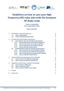
Guidelines on how to sync your High Frequency (HF) radar data with the European HF Radar node (Version1.2).
(Balearic Islands Coastal Observing and Forecasting System, SOCIB, Palma de Mallorca, Spain, 2020)
This document is a step-by-step guide to start transferring HF radar (HFR) data from your
network to the EU HFR node .
The EU HFR node acts as the focal point for the European HFR data providers, implementing
the HF ...