Search
Now showing items 1-7 of 7

Compilation of spatial data on marine recreation activities: Phase 2 Mapping marine recreation guidance: How to supply spatial data.
(Marine Management Organization, 2013)
This zip file contains a Marine Management Organisation (MMO) data guideline in two formats: a pdf file and an xls spreadsheet. The files contain identical information, but both formats are provided to meet different users’ ...
Spatial trends in shipping activity (AIS derived shipping activity – data standards).
(Marine Management Organization, 2013)
This guideline comprises two pdf files, one is a report entitled ‘AIS Derived Shipping Activity - Data Standards’ and the other is a ‘Draft data guideline for the presentation of AIS Derived Vessel Spatial Data’. These ...
MEDIN data guidelines for bathymetry data. Version 2.0.
(MEDIN, 2013)
This guideline is a data archive standard for bathymetry data. Used correctly the guideline facilitates easy use and reuse of the data. A template to record metadata is also provided if required.
MEDIN data guideline for the recording of water sample data. Version 4.1.
(MEDIN, 2013)
This guideline is a data archive standard for the collection of discrete water samples which are subsequently used for chemical or biological determination. Used correctly the guideline facilitates easy use and reuse of ...
MEDIN data guideline for the recording of moored instrument data. Version 4.0.
(MEDIN, 2013)
This guideline is a data archive standard for oceanographic data from moored instruments. If used correctly the data will be easily used and reused.
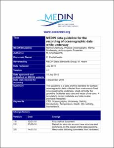
MEDIN data guideline for the recording of oceanographic data while underway. Version 4.1.
(MEDIN, 2013)
This guideline is a data archive standard for surface oceanographic data collected from instruments fixed on a vessel while underway. Used correctly the guideline facilitates easy use and reuse of the data. A template to ...
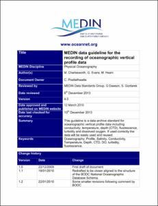
MEDIN data guideline for the recording of oceanographic vertical profile data. Version 4.0.
(MEDIN, 2013)
This guideline is a data archive standard for oceanographic vertical profile data including conductivity, temperature, depth (CTD), fluorescence, turbidity and dissolved oxygen. If used correctly the data will be easily ...